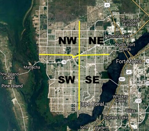
Navigating the Street names in Cape Coral
Cape Coral can be a challenge for driving directions since it has over 400 miles of waterfront canals. If you drive a short distance in any direction you will probably hit water. Before GPS became popular ….. out of town Real Estate Agents would tell me that they would get belly aches when they had to show homes in our beautiful City because they could not find their way around. They would say: “there is nothing worst than looking across a canal and seeing the house that is scheduled to show but didn’t know how to get there…..haha! It really is not the bad. Just remember you want to navigate off of the main roads. Here are more tips to help you navigate, just in case you forgot your GPS at home:
Cape Coral is divided into four quadrants (NW, NE, SW, SE).
The NW/NE are divided at Santa Barbara Blvd, going east/west.
The NE/SE are divided at Hancock Bridge Pkwy, going north/south.
The SE/SW are divided at Santa Barbara Blvd, going east/west.
The NW/SW are divided at Embers Pkwy, going north/south.

Type of Directions
Ave, Blvd, Ct, Pl = run north/south
St, Ln, Ter, Pkwy = run east/west
I always remember the acronym ABC+P for up and down.
How to find an address….
Watch for the crossing street…what we call the Block.
For example:
If you are looking for 3515 Del Prado Bvd S = you drive down Del Prado and look for the cross St around 35th (called the 3500 block).
If you are looking for 2817 Skyline Blvd… you drive down Skyline Blvd and look for the cross street around 28th (called the 2800 block).
Hope these tips help you…………….
For more info contact Realtor Deb Cullen at (239) 233-2322 or here…
